Facebook
 Linked In
 Twitter
 YouTube

IndiAgri Bureau
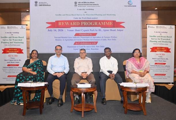
Jaipur: The National Rainfed Area Authority (NRAA), as the knowledge partner of the Department of Land Resources (DoLR), organised a national brainstorming workshop on the use of satellite and drone technologies for watershed planning and monitoring under the World Bank-supported REWARD (Rejuvenating Watersheds for Agricultural Resilience through Innovative Development) programme.
The workshop brought together policymakers, scientists, technical experts, and officials from several states to discuss how geospatial technologies can improve watershed planning, implementation, monitoring, and evaluation. The discussions are expected to contribute to the preparation of the National Technical Guidelines (NTG), which will serve as a key reference for the upcoming Watershed Development Component of PMKSY (WDC-PMKSY) 3.0.
Welcoming the participants, Dr. Susama Sudhishri, Technical Expert (Watershed Development) and Project In-charge for the REWARD programme at NRAA, outlined the objectives of the workshop and stressed the importance of adopting modern technologies for more accurate and efficient watershed management.
Addressing the gathering, Dr. Chandra Shekhar Kumar, Chief Executive Officer of NRAA, emphasised the need for the National Technical Guidelines to clearly define when and how satellite-based and drone-based surveys should be used across different agro-climatic regions. He said standardised protocols would help ensure consistency in watershed planning, execution, monitoring, and impact assessment nationwide.
The workshop also witnessed participation from senior officials representing central and state governments, research institutions, and development organisations. Among those present were Dr. Joga Ram, Secretary and Commissioner, Panchayati Raj Department, Government of Rajasthan; Y. V. K. Shanmukh Kumar, Director (Watersheds), Andhra Pradesh; Kalpana Agarwal, Director, Watershed Development and Soil Conservation Department, Rajasthan; Dr. S. Bandyopadhyay, Director, Mahalanobis National Crop Forecast Centre (MNCFC), Ministry of Agriculture and Farmers Welfare; and Sushila Yadav, Chief Engineer and Joint Secretary (Soil and Conservation), Government of Maharashtra.
Experts exchanged views on the latest advancements in remote sensing, drone mapping, and geospatial analytics, focusing on how these technologies can support scientific watershed planning, improve monitoring accuracy, and enhance the long-term sustainability of watershed projects.
The recommendations emerging from the workshop will help shape future technical standards for watershed development programmes and support the government's efforts to build climate-resilient agricultural landscapes through technology-driven resource management.